

Почніть з маршруту, який використовує денне світло: петля довжиною 6-9 кілометрів біля станції, яку можна пройти за 3-5 годин. Маршрут контролює вплив зовнішніх факторів, підкреслює стабільний темп і має спуски, які закінчуються біля вершин.
Місцеві гіди діляться розповідями про маршрути, які пролягають через долини та піднімаються до відкритих вершин, з яких відкриваються краєвиди на вкриті інеєм схили. Якщо ви хочете різноманітності без надмірних зусиль, поєднайте маршрут довжиною 8-12 кілометрів з теплою зупинкою в сауні або хатині. Для груп додайте підземну ділянку в замерзлій печері та зафіксуйте години, витрачені на пересування між локаціями в мережі маршрутів.
Кожен день включає заходи, які збалансовують навантаження та відновлення: підйом на оглядовий майданчик, швидкий спуск і легка стежка, щоб завершити день з підкріпленням сил. План передбачає кілька коротких відрізків, а не одне важке випробування, без важкого спортивного спорядження, забезпечує зручні перерви на перекус і гарантує безпечні переходи по пересіченій місцевості. Практичне правило: не більше 2-4 годин безперервного руху на день і довша перерва в місці біля станції.
Коли погода погіршується, вибирайте альтернативні маршрути в межах долинної мережі, щоб залишатися з видом на мальовничі долини, залишаючись у безпеці. Якщо ви плануєте коротку підземну екскурсію, бронюйте місця заздалегідь і беріть із собою додатковий сухий перекус. Завжди майте запасний варіант у теплій хатині, щоб сховатися від холоду та обговорити розповіді дня.
Завершіть підсумком у місці, яке служить центром для майбутніх маршрутів; план розроблений таким чином, щоб бути гнучким: він може варіюватися від кількох кілометрів до більше десятка, залежно від денного світла та снігового покриву. Загальна ідея полягає в тому, щоб використовувати поєднання занять, які підтримують частоту серцевих скорочень, не виходячи за межі своїх можливостей, поважаючи при цьому моделі сплячки у вищих альпійських зонах.
Практичне планування та виконання зимових пригод
Виберіть петлю з гарантованим снігом на горбистій місцевості, почніть на світанку та встановіть суворий час повернення на обід, щоб тримати втому під контролем. Запакуйте компактний набір для безпеки, карту, компас і телефон з офлайн GPS, а також невеликий бівак або аварійну ковдру.
Спорядження має бути компактним, але повним: снігозахисна куртка з утеплювачем, водонепроникні штани, міцні черевики з підтримкою гомілкостопу, гетри, шолом, маячок, лопата, щуп, налобний ліхтар із запасними батарейками, карта, компас і офлайн GPS. Включіть компактний бівак і аварійну ковдру, а також базову аптечку. Візьміть із собою 2-3 літри води та енергетичні перекуси, щоб підтримувати сили на різноманітній місцевості, яку ви плануєте подолати.
Плануйте маршрут через долини та в гори, враховуючи прогноз погоди та можливості вашої групи. Використовуйте діапазон висот близько 300-900 м для легких і помірних днів у сніжних умовах. Встановіть чітку точку повороту, якщо темп сповільнюється або видимість падає. Тримайте всіх разом - один лідер, один замикаючий і кілька людей між ними, щоб залишатися на зв'язку під час проходження складних ділянок. Якщо видимість погіршується, припиніть рух і поверніться тим самим шляхом.
Регіональні примітки: у Куусамо маршрути пролягають через ялинові ліси та навколо замерзлих озер; у Таннхаймері вибирайте широкі лісові дороги та лугові лінії; у Квітф'єллі або Альпах шукайте альпійські стежки зі стабільними ухилами та надійним снігом; великодні періоди часто приносять більше сонця, але більший трафік у хатинах, тому плануйте логістику відповідно. Переконайтеся, що у вас є гарантований сніг, перевіривши поточну глибину снігу та фактори вітрового навантаження; шукайте вікна сонячного світла протягом дня, щоб максимізувати видимість і комфорт.
Фізична підготовка: підтримуйте кардіобазу з 3-4 щотижневими заняттями, додайте роботу на ноги та корпус і практикуйте баланс на снігу, використовуючи вправи на суші. Плануйте відпочинок після довгих днів і підтримуйте водний баланс. Темп має залишатися стабільним протягом 3-5 годин на легких і помірних маршрутах; використовуйте перерви для розтяжки, сушіння рукавичок і відновлення водного балансу. Якщо ви помітили оніміння пальців рук або ніг або тремтіння, зупиніться та зігрійтеся, перш ніж продовжувати.
Безпека та командна робота: розподіліть ролі, забезпечте чіткий зв'язок, переконайтеся, що у кожного є маячок і він знає, як ним користуватися; відстежуйте пройдені етапи; якщо група відстає більше ніж на кілька хвилин або якщо погода погіршується, відступайте. Нотатки після дій слід записувати, щоб покращити наступний раз і поділитися розповідями про успіхи та невдачі з майбутніми учасниками. Ви та всі інші повинні залишатися в межах своїх можливостей.
Після кожної подорожі записуйте, що пройшло добре, а що потрібно скоригувати; збирайте розповіді від команди, щоб покращити вибір спорядження, темп і критерії повороту для наступного переходу через гори та долини.
Контрольний список спорядження для турів у холодну погоду: верхній одяг, черевики, палиці та списки речей
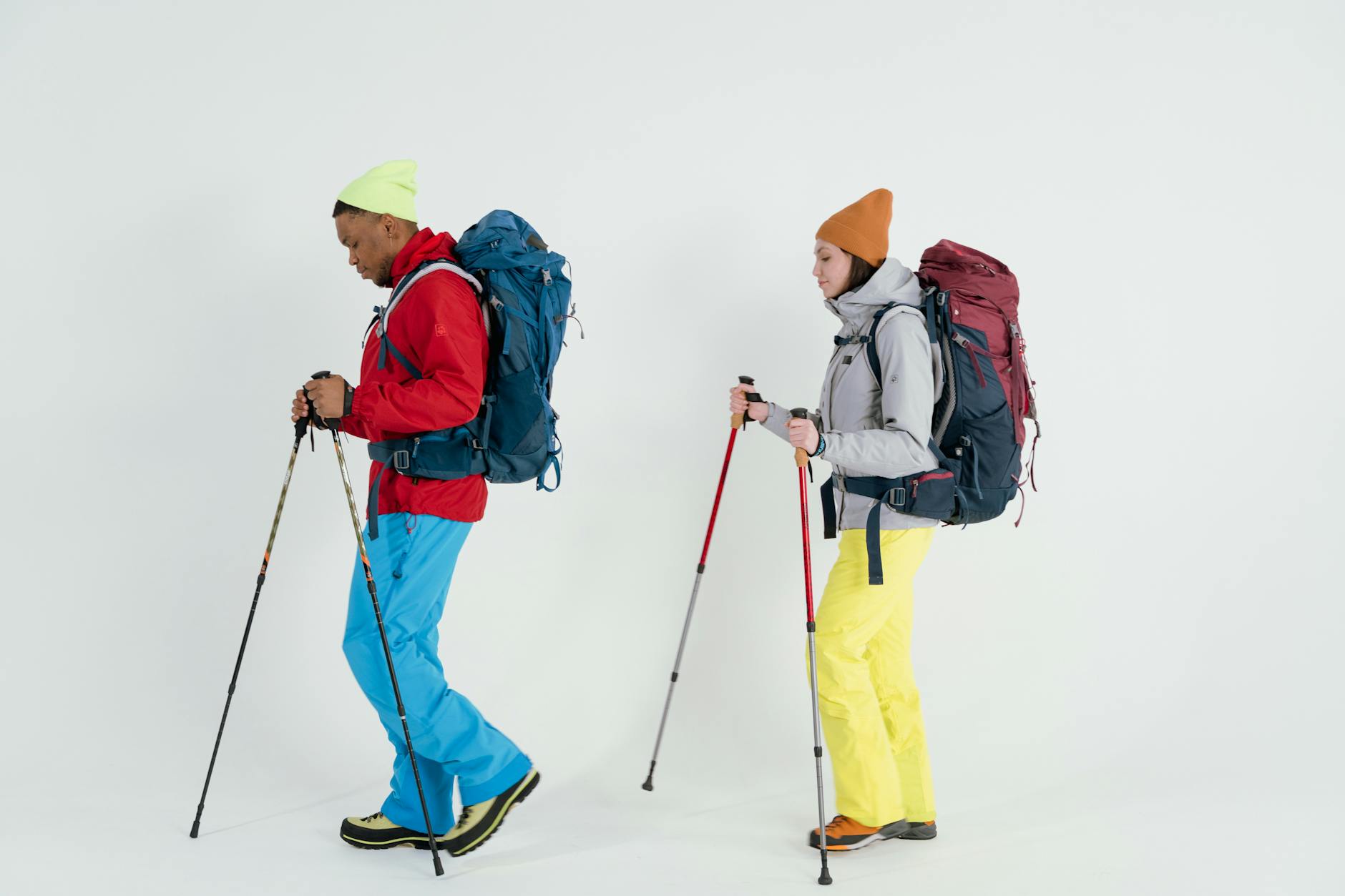
Почніть з тришарової системи: базовий, середній і зовнішній шар. Виберіть водонепроникну, вітрозахисну куртку з герметичними швами та вентиляцією; додайте теплий утеплений шар для пауз і сильних вітрів на хребті та переконайтеся, що посадка забезпечує повний діапазон рухів, не стискаючи базовий шар.
Вибір верхнього одягу збалансовує повітропроникність і тепло. Тришарова куртка з 2- або 3-шаровою конструкцією з DWR зберігає вас сухими на відкритих ділянках; для подорожі через гори в Маунтополісі запакуйте пухову або синтетичну утеплену куртку, яка компактно складається та залишається теплою, коли ви зупиняєтеся. Включіть балаклаву, шапку та рукавички або рукавиці; гетри допомагають запобігти потраплянню снігу в черевики. Чудові альпійські краєвиди вимагають надійного тепла та повітряного потоку під час швидких рухів і тривалих очікувань. Цей баланс важливий.
Черевики повинні бути водонепроникними та утеплені, розраховані на мінусові температури. Виберіть модель з високим вирізом і жорсткою підошвою з місцем для товстих шкарпеток і теплих пальців; приміряйте з підкладками та розгляньте гетри для глибокого снігу. Переконайтеся в сумісності з кішками, якщо ваш маршрут може вимагати зчеплення; візьміть із собою запасну пару шкарпеток і використовуйте вологовідвідні вовни, щоб запобігти замерзанню ніг.
Трекінгові палиці: регульована довжина приблизно від 100 до 140 см, карбонові або алюмінієві, з карбідними наконечниками для льоду та гумовими наконечниками для слідів від черевиків. Використовуйте антишок, якщо ви віддаєте перевагу більш плавному перенесенню; тримайте ремінці щільно прилягаючими та не забувайте послаблювати натяг під час перетину нерівної місцевості.
Рюкзак 40-50 л з водонепроникним чохлом; організуйте за допомогою сухих мішків і пакувальних кубиків. Предмети першої необхідності включають компактну плиту або паливо, посуд і тарілку для їжі; візьміть із собою щонайменше 1,5 л води; ізольовану пляшку; енергетичні батончики; суміш для стежок; запасні батарейки; аптечку; налобний ліхтар із додатковими батарейками; карту, компас або GPS-пристрій; і аварійний притулок або бівак. Для такого місця, як Ріттісберг, готова до вживання страва з лосося може покращити відновлення після довгих днів; додайте набір посуду та невеликий рушник.
Кожен мандрівник повинен адаптувати список до своїх занять і погоди. Ранні старти максимізують світло та зменшують вплив вітру; плануйте заздалегідь ночівлі в хатинах або саунах і гарячі напої та скористайтеся можливістю висушити спорядження на грілках для рук. Запакуйте додаткові батарейки для налобних ліхтарів на випадок, якщо ви затримаєтеся після настання темряви; тепла шапка та друга пара рукавичок стануть у нагоді для кількох днів із низьким сонцем на мальовничих маршрутах поблизу гірських зон.
Крос-кантрі траси світового класу: як вибирати маршрути та регіони
Почніть з вибору регіонів з надійним снігом, чіткими знаками та густою мережею трас, таких як Альпи або Фінляндія. Плануйте 2-3 денні маршрути з щоденними відстанями 20-28 км по доглянутих трасах, залишаючи місце для коротших варіантів, якщо погода зміниться. Шукайте маршрути, які поєднують паркові ділянки, сільські відрізки та лісові стежки, щоб збалансувати темп і краєвиди, які можуть бути надзвичайно різноманітними та пропонувати корисний досвід.
Щоб вибрати маршрути, нанесіть на карту різноманітність місцевості та доступність. Віддавайте перевагу мережам, які пропонують легке залізничне сполучення, паркування біля початку трас і варіанти обіду поблизу. У Фінляндії чи Альпах шукайте траси, які добре позначені, використовуються регулярно та підтримуються парковими службами, з чіткими знаками та частими зупинками для відпочинку за селами. Якщо ви каталися на подібних мережах, ви знаєте, чого очікувати. Хоча поєднання може бути вимогливим, воно підійде досвідченому мандрівнику.
Бронювання заздалегідь є важливим, особливо в пікові періоди. Використовуйте регіональні туристичні ради або місцеві платформи бронювання, щоб забронювати ліжка, харчування та абонементи на траси. Якщо ви подорожуєте між регіонами, нанесіть на карту розклад поїздів і щоденні трансфери, щоб залишити енергію на наступний день.
Обладнання має значення: перевірте спорядження перед відправленням - віск, черевики та палиці - плюс запасну батарею та компактний набір для обіду для довших ділянок. Майте звичку заряджати запасні батареї в середині дня, коли ви проїжджаєте через село. У магазинах Anna в придорожніх містах часто є віск і прості закуски, що полегшує поповнення запасів у дорозі. Після дня на трасі замініть або зарядіть батареї за потреби.
Поради щодо дизайну траси: поєднуйте альпійські підйоми з рівнинами біля озера, щоб змінювати зусилля; якщо ви спортсмен, наполегливо працюйте на гірських ділянках, але полегшуйте на спусках, щоб закінчити сильно. Спробуйте інший маршрут після дня відпочинку, щоб розширити свій досвід і підтримувати високу мотивацію. Залиште час, щоб насолодитися спостереженнями за кроликами вздовж тихих петель.
Регіональні примітки: Альпи пропонують високогірні мережі з довгими спусками до альпійських долин і важчими підйомами; Фінляндія пропонує горбисті траси через соснові ліси та замерзлі озера, що чудово підходить для стабільного прогресу та щоденного ритму. Обидва регіони надають надійні вікна бронювання та можливості зупинитися в невеликих селах і гостьових будинках.
З чого почати: базуйтеся в долині поблизу парку та кількох сіл, а потім зробіть петлю до сусідніх трас і поверніться до свого житла щовечора. Це спрощує логістику та дозволяє уникнути додаткових зусиль на наступний ранок. Якість траси та оновлення безпеки можна перевірити в місцевих магазинах або на онлайн-дошках в магазині Anna, коли ви плануєте наступний день.
Темп, зупинки для відпочинку та щоденні відстані: плануйте 15-25 км на день
Обов'язково плануйте щоденні етапи по 15-25 км зі стабільним темпом, який зберігає енергію для ділянки в глибинці та дозволяє надійні зупинки, щоб допомогти керувати енергією та запобігти втомі. Закінчуйте кожен сегмент при денному світлі, щоб тримати розум зосередженим на наступному етапі та зменшити втому.
- Цільова щоденна відстань: 15-25 км; коригуйте з урахуванням набору висоти та глибини снігу; залишайтеся гнучкими.
- Перша зупинка: село, розташоване вздовж траси, яке пропонує притулок, гарячі напої та швидкий перекус.
- Друга зупинка: хатина біля озера або курорт для тривалішого відпочинку з кавою та закусками.
- Притулок у глибинці як резервний, коли наступне село далеко; сплануйте безпечну точку виходу.
- Для коротших етапів або логістики трансфери поїздом або місцеві шатли надають можливість скоротити день.
- Регіональне натхнення: Карелія з озерами та лісами; Куусамо служить воротами; Хохріндль, Циллерталь і Бергкастель демонструють альпійські стилі, які можна відтворити на довших маршрутах.
- Ідеї для перекусу: скибочки лосося, горіхи, сухофрукти; гарячий напій відновлює енергію.
- Час закінчення: вирушайте до наступного притулку до пізнього дня, щоб максимально використати денне світло над лінією дерев.
Безпека, навігація та підготовка до погоди: навички роботи з картою, використання маячка та обізнаність про денне світло
Завжди майте з собою актуальну топографічну карту, надійний компас і персональний локаторний маячок; перед відправленням проведіть з усією командою репетицію групового пошуку. Ця установка дає вам можливість триматися разом і запобігає пропуску членів групи, коли видимість падає.
Розвивайте навички роботи з картою за допомогою триангуляції, підрахунку темпу та перетину. Позначте шляхові точки траси, перевірте відстані до місця призначення та запишіть часовий бюджет у годинах. Використовуйте особливості місцевості, щоб підтвердити свій маршрут, а не покладайтеся лише на пристрої.
Перевірте надійний прогноз і оцініть обізнаність про денне світло. Оцініть кути сонця та сплануйте свій вихід, щоб закінчити з достатньою кількістю денного світла, щоб дістатися до затишного притулку. Запакуйте налобний ліхтар із запасними батарейками та резервний ліхтар; намагайтеся прибути до наступної визначної пам'ятки до настання сутінків, особливо в районах з невеликою кількістю сигнальних точок.
Використання маячка вимагає практики: увімкніть, перевірте та встановіть режим передачі/пошуку як частину своїх тренувань. У груповому сценарії розподіліть ролі: один лідер, один оператор маячка, один пошуковик, один спостерігач. Тримайте маячок швидкого доступу в зовнішній кишені, а не закопаним у рюкзаку, щоб прискорити реагування, якщо хтось зникне.
Упакуйте спорядження стратегічно: карта, компас, маячок, налобний ліхтар, додаткові батарейки, свисток, перша допомога, ізоляційні шари, водонепроникна куртка та енергетичне паливо, таке як закуски на основі сочевиці. Підтримуйте водний баланс і зберігайте затишне тепло тіла; відрегулюйте шари, щоб запобігти перегріву, зберігаючи при цьому рухливість.
Під час нанесення маршрутів на карту використовуйте такі орієнтири, як ливарні заводи з видом на вкриту інеєм долину або лінію ялиць уздовж стежки. Якщо ви рухаєтеся через зони Дорсет, Кончезеро або Ріттісберг, враховуйте глибину снігу та точки доступу. Можуть з'явитися спостереження за дикою природою, як-от кролики та білки; відрегулюйте свій темп, особливо ноги, щоб залишатися збалансованими на нерівній землі, утворюючи безпечну лінію. Якщо ви прибули на перехрестя та побачили свіжі сліди, ви знаєте, що перебуваєте в правильному місці; інакше поверніться до відомої точки та переоцініть. Зграї птахів над головою можуть натякати на зміну погоди, несподіванку, яка змінює час і основні моменти маршруту. Весь цей процес може вимагати коригування планів на ходу. Це дає чудовий досвід; фактична практика поводження з обладнанням в умовах замерзання підвищує готовність і зменшує ризик.
Харчування, гідратація та нашарування для довгих зимових днів
Почніть з 350 мл електролітного напою вранці після пробудження, потім 150 мл кожні 25 хвилин протягом перших двох годин на схилах, щоб підтримувати заряд і зберігати гостроту прийняття рішень для кожної сесії.
Цілі гідратації: 1200-1600 мл на півдня, 2000-2800 мл на повний день; включіть 200-300 мл гарячого напою в середині дня, щоб стабілізувати температуру тіла. Використовуйте фонтани, коли крани працюють, і носіть із собою компактний фільтр для довших кілометрів на відкритих маршрутах; тримайте запасну пляшку в просторому рюкзаку. У досить холодні дні попередньо нагрійте пляшку об'ємом 500 мл в ізольованому чохлі, щоб запобігти замерзанню рук під час перерв. Після багатьох років польових випробувань цей підхід надійно демонструє стабільну енергію та дозволяє уникнути втоми на тривалих підйомах.
Паливо має бути смачним і легко засвоюваним: сухофрукти, горіхи, цільнозернові батончики, банан і невеликий квадратик шоколаду для відновлення глюкози після крутих підйомів на схил. Їжте щось кожні 45-60 хвилин під час високих фізичних навантажень і поєднуйте з солоними закусками, щоб підтримувати електролітний баланс і зменшити судоми. Цей розпорядок підтримує вас зарядженими та допомагає групі триматися разом на довгих кілометрах траси та підйому.
Нашарування зберігає комфорт під час змін сонця, тіні та вітру: базовий шар (меринос або синтетика, вологовідвідний), середній шар (фліс або легкий пух), зовнішній шар (3-шарова куртка). Базовий шар, який використовується щодня, зберігає шкіру сухою, а в центральній кишені зберігається невелика закуска для швидкого доступу. Налаштування просте; як і сам, він виявився надійним після багатьох років на крижаних схилах. Під час зупинок для відпочинку або в підземних кімнатах для обігріву поблизу центру старанно регулюйте шари, щоб уникнути перегріву, особливо під час великодніх поїздок Альпами, де з'являються можливості досліджувати місця подалі від жвавих трас.
| Час | Гідратація (мл) | Перекус | Базовий шар | Середній шар | Зовнішній шар | Примітки |
|---|---|---|---|---|---|---|
| 06:30-08:00 | 400 | банан + гель | меринос або синтетика | легкий фліс | водонепроникна куртка | тепло в центрі, легка рухливість на схилі |
| 08:00-11:00 | 500 | мигдаль, фініки | базовий шар залишається сухим | середній утеплений | вітрозахисний зовнішній | підтримуйте енергію під час підйомів і польотів |
| 11:00-13:00 | 400 | смачний батончик | легший базовий | середній фліс | куртка або легка парка | відпочинок, поповнення води |
| 13:00-15:00 | 350 | квадратик шоколаду | той самий | додатковий за бажанням | додатковий вітрозахисний шар | відновлення на свіжій трасі |


